© Copyright Todd Neel
NOTE: Two days entries posted here.
9/3/2024 Tuesday –
I drove and drove and drove today, reaching Mile 0 of the Alaska Highway, formerly known as the Alcan Hwy. This was in the town of Dawson Creek, just back inside British Columbia from the province of Alberta. This road was built during World War II by the U.S. Army and American and Canadian civilians out of concern about invasion of Alaska by Japan. For many years it remained as a dirt road, famous for rock chips in windshields, but it is now paved as a modern 2 and 3 lane highway. It’s route goes from Dawson Creek, BC for 1387 miles to Delta Junction, Alaska.

I made it about 20 miles up this road tonight past Dawson Creek, camping about 5 km off the modern main highway on a side route of “Old Alaska Highway” which ended at a bridge closure near a campground of the Kiskatinaw Provincial Park. Almost paid $10 (senior rates) for a campsite with a picnic table, but found an adequate flat parking spot at the end of the road next to the closed bridge – no fee!
Drove 326 miles today.
9/4/2024 Wednesday –
Drove a lot today, yet had a very nice nap beside a pond just off the Alaska Highway. (I like the sound of that: “… Nap Beside a Pond … .)
Note: I struggle right now trying to find photos of that beautiful pond to be able to share with you, and I have echoes of my supervisor from when I was working in my mind stating: “If it isn’t documented, then it didn’t happen …” Yes it did! I was there! I can play the movie in my head, can’t you see it?
I saw a road sign stating “Next gas at …” with more miles/kilometers than my digital gas gauge told me I had left in the tank before empty, so I stopped to fill up at Buckinghorse River Restaurant. There is a lot of oil and gas exploration up here and a lot of large tanks all over the place, so I missed the gas pump next to an above-ground storage tank. The pump was old fashioned without any digital readout or chip reader to take the tap of my credit card, just a sign that said “Give credit card to cashier in restaurant”. So I walked inside and talked to a human being, not like a lot of gas stations these days. She was from Alberta but said she likes living out here in the middle of nowhere. I asked and she had to point out that we were between Sikanni Chief and Truch on the map, but Buckinghorse was not on my map. (There are not mile posts every mile or kilometer here like on traditional American highways, so if you were in an accident or need a repair it would be difficult to tell the RCMP or tow truck driver how to find you, if you could reach them by cell phone – it’s pretty isolated up here!)

Gas is expensive! This fill up cost $196! (Of course, there is the calculation of the Canada/U.S. exchange rate, and litres instead of gallons, etc. But, I’ll let the credit card company figure that out – I trust them, right?)
Comment/question on reasons for above ground tanks: Is it because of the permafrost?
As the sun was setting I crossed a bridge over a large river, and looking down I saw a very large gravel bar with about a half-dozen campers spread out beside the river. A black bear crossing the road stopped my speed on the far side of the bridge allowing me to turn around and find my way down to the gravel bar, perfectly flat, solid for driving on, and very spacious so we campers didn’t have to hear each other fart.
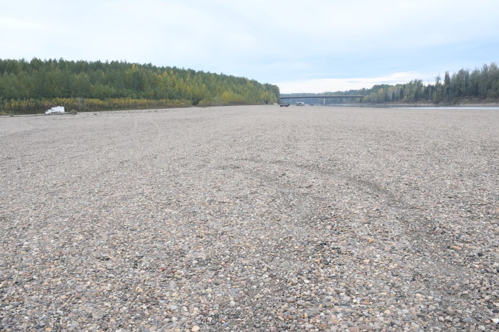
This is the Muskwa River.

Clear skies tonight, observing constellations and the Milky Way. Stars were so thick and numerous that I lost some of the constellations that I was usually familiar with.
Drove 271 miles today.

Leave a reply to Marlene Stein Cancel reply